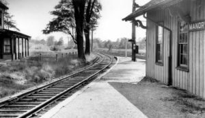
The hamlet of Manorville was a small farming community for many years. The area of the hamlet once laid within the huge tract of land known as Manor St. George, a land grant given to Col. William Tangier Smith in 1693 for recognition of his service as governor of Tangier in Morocco. In 1844, the Long Island Rail Road built a station called St. George's Manor," which was situated off of Tyerson Avenue. However, Seth Raynor, the station agent who was a patriot during the American Revolutionary War, disliked the name due to its similarity to the British and their colonial dominance and decided to paint over the sign, leaving only the word "Manor". The hamlet changed its name to "Manorville" with the opening of its post office in 1907, but timetables and Long Island Rail Road documents retained the name "Manor" until 1907 or 1908.
 The Hamlet is at the western edge of, and partially within, the Long Island Central Pine Barrens. The land is heavily wooded, and features some wetlands, particularly in the northern section near the Peconic River. Much of the northeastern portion of the hamlet is in the Pine Barrens' "Core Preservation Area", where no further development is allowed. This area also serves as a primary source for Long Island's groundwater preserve.
Manorville is known for its close proximity to the Hamptons, earning the nickname "The Gateway to the Hamptons".
Median real estate property taxes paid for housing units with mortgages in 2015: $10,441 (2.4%)
Median real estate property taxes paid for housing units with no mortgage in 2015: $5,475 (1.8%)
Click here if you're interested in learning more about Manorville, NY.